How Printmaking Shaped Cartography — and How Father Kino Proved California Was Not an Island
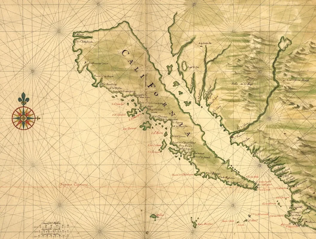
For centuries, Europe believed that California was an island. This idea appeared again and again on printed maps, atlases, and globes from the sixteenth and seventeenth centuries, reproduced through engraving and disseminated across the continent. The myth endured not because it was accurate, but because printmaking gave it authority.
The story of how this error was corrected reveals the central role of printmaking in cartography and science — and the decisive intervention of a Jesuit missionary working in what is now Arizona and Sonora.
Printmaking and the Power of Maps
Before photography or satellite imagery, engraved maps shaped how Europeans understood the world. Copperplate engraving made it possible to create detailed images that could be reproduced and distributed widely. Once a geographic idea appeared in print, especially in a respected atlas, it carried weight.
The idea of California as an island entered European cartography through early travel accounts and conjectural geography. After it was engraved and published, it spread quickly. Mapmakers copied one another. The image repeated itself across decades.
Correcting that image meant putting a different one into circulation.
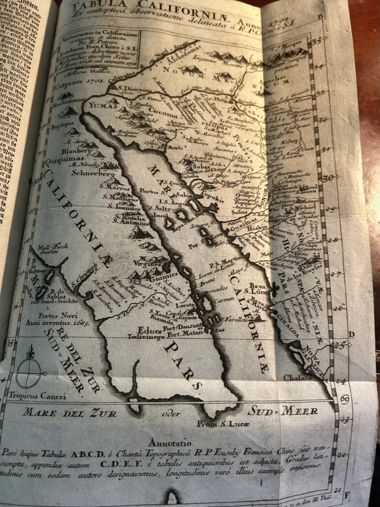
Below is an example from my personal collection, what I refer to as the Kino map. This engraving appears in the German translation of Curious and Edifying Letters, the Jesuit journal that documented missionary activity around the world. It is the first German printing of the Kino map, issued in 1727.
If you zoom in, you will see S. Xavier du Bac, which is the mission just outside of Tucson, Arizona.
The Jesuit Missionary Who Changed the Map
That authority came from Eusebio Kino, a Jesuit priest, scientist, and cartographer active in the late seventeenth and early eighteenth centuries. Born in the Tyrol and trained in mathematics and astronomy within the Society of Jesus, Kino belonged to a generation of missionaries whose intellectual formation was as rigorous as their religious vocation.
From mission bases in Sonora and what is now Arizona, he spent decades traveling across the northern frontier of New Spain. These journeys were long, often dangerous, and conducted through deserts, river valleys, and mountain passes that were scarcely known to Europeans. Kino rode thousands of miles on horseback, keeping careful notes on distances, terrain, water sources, and settlements. He recorded astronomical observations to calculate latitude and integrated local geographic knowledge into his understanding of the region.
At the time, many European maps continued to depict California as an island separated from the mainland by a strait. Kino’s repeated expeditions toward the head of the Gulf of California and along the river systems that fed into it provided consistent evidence of overland continuity. Through cumulative observation, he demonstrated that California was in fact a peninsula connected to the continent.
His conclusions carried weight because they were grounded in experience and documentation. Kino produced manuscript maps that synthesized his travels, measurements, and reports. These materials were later engraved and circulated in Europe, where they began to influence the broader cartographic tradition. As printed maps incorporating his findings entered scholarly and commercial networks, they contributed to a gradual correction of the long-standing insular depiction.
Kino’s authority therefore rested on sustained fieldwork and the ability to translate travel into cartography. By placing firsthand geographic knowledge into print, he reshaped European understanding of the American West and established a more accurate vision of the region’s physical reality.
Tucson, Arizona, and the Jesuit Landscape
Kino’s work unfolded across the region that includes modern Tucson and the Sonoran Desert. The Jesuit mission system provided not only religious infrastructure, but scientific and geographic intelligence. Missions such as Mission San Xavier del Bac and the broader network of mission churches created stable bases from which exploration and mapping could occur.
This landscape mattered. Kino’s ability to prove California’s geography depended on overland travel through what are now Arizona and northern Mexico. The desert, often imagined as empty, became the proving ground for one of the most important corrections in early modern cartography.
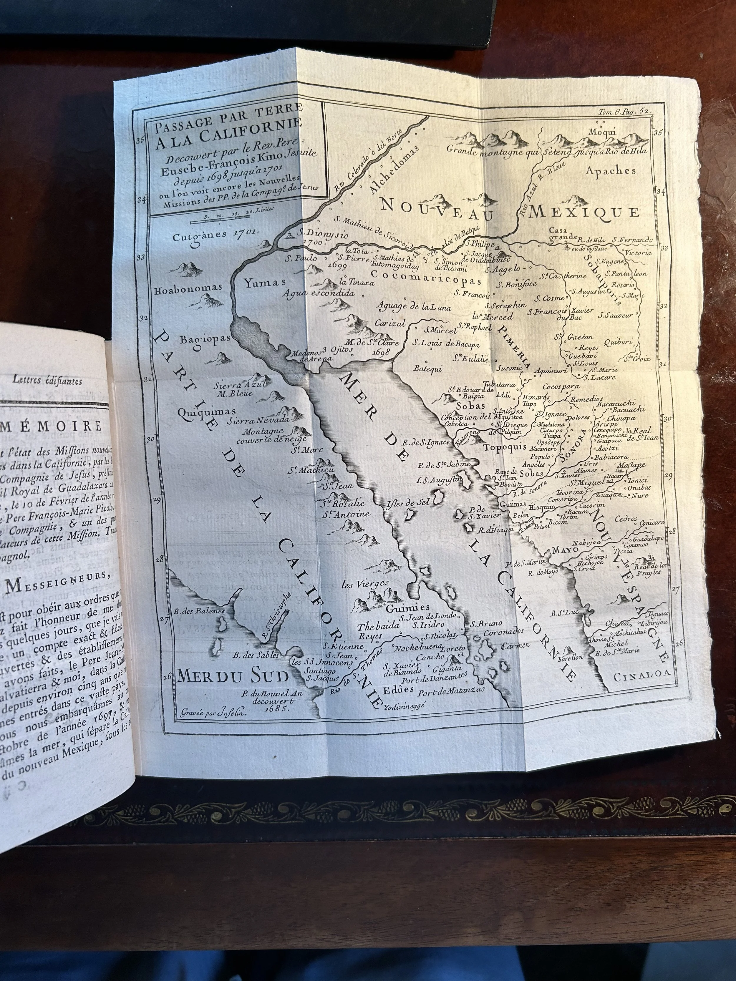
Below is the 1789 French printing of Curious and Edifying Letters showing the famous Kino map, otherwise known in French as “Passage par terre a la Californie”
From Observation to Printed Truth
Kino’s maps, once engraved and printed, entered European circulation. They contradicted decades of printed authority and forced mapmakers to revise their plates. This process was slow, but decisive. Gradually, the island of California disappeared from maps.
This transformation underscores the importance of printmaking. Observation alone was insufficient. Knowledge became real only when it was engraved, printed, and distributed. Copperplate maps, scientific illustrations, and natural history prints formed the backbone of early modern science.
Baroque Print Culture and Scientific Authority
The period in which Kino worked was deeply shaped by Baroque print culture. Engraved maps shared visual language with Baroque art, architecture, and scientific illustration. Ornament, precision, and authority coexisted. Maps were not neutral diagrams; they were persuasive objects.
This same print culture produced the natural history engravings, botanical woodcuts, and scientific plates that survive today. These works reflect a world learning how to see accurately, measure carefully, and correct inherited errors.
![Conrad Gesner [1516-1565] - Cuckoo, ornithology, folio with woodcut - 1669](https://images.squarespace-cdn.com/content/v1/696fb74856703d5db9f3c89f/4592ac14-c46d-4939-82b2-0e86c8b185f8/cuckoo+1.jpg)
Cuckoo (Ornithology)
From Historiae Animalium / Allgemeines Thier-Buch
Conrad Gesner
Zurich, later German edition published 1669
Woodcut on folio leaf
Later hand coloring
Description
This folio woodcut depicting a cuckoo originates from the German edition of Conrad Gesner’s monumental zoological project, issued in 1669 as part of the Allgemeines Thier-Buch, a continuation and vernacular expansion of Gesner’s Historiae Animalium. Gesner’s original Latin editions, first published in Zurich in the mid-sixteenth century, are widely regarded as the first modern works of zoology.
Gesner, a physician and professor at the Carolinum in Zurich, sought to compile a complete inventory of all animals known to Renaissance Europe. His work was unprecedented in scope and method, combining classical sources, medieval knowledge, traveler accounts, and direct observation. Equally important, Historiae Animalium represents the first true bibliography of natural history, establishing standards for scientific citation and comparison.
The cuckoo was of particular interest to early naturalists due to its unusual behavior, migratory patterns, and reproductive habits, which challenged prevailing assumptions about birds. Gesner’s treatment reflects this curiosity, presenting the bird as a distinct and recognizable species rather than a symbolic or allegorical creature.
The present impression has been hand colored at a later date, adding visual warmth and individuality to the image while preserving the clarity of the original woodcut. Such later coloring was often undertaken to enhance legibility and appeal for collectors, and each example remains unique.
Gesner’s ornithological woodcuts are prized for their quiet authority and observational focus. They mark a decisive shift away from myth toward empirical study and remain foundational documents in the history of zoology and scientific illustration.
Condition
Good overall condition. Even age toning consistent with the period. Please view images carefully.
Details
Medium: Woodcut with later hand coloring
Format: Folio leaf
Date: 1669
Dimensions: 13.39 × 7.48 inches (34 × 19 cm)
Subject: Ornithology, Cuckoo
Status: Available
Why This History Still Matters
Understanding how California ceased to be an island reveals why original prints and maps are so important. They are not decorative relics. They are documents of intellectual struggle, showing how knowledge advanced through the slow correction of error.
In Arizona and Sonora, this history remains tangible. Jesuit missions, Baroque architecture, desert landscapes, and surviving prints all belong to the same story. They remind us that modern geography was forged through printmaking, persistence, and the courage to challenge accepted truths.
Today, original Renaissance and Baroque prints allow us to encounter this process directly. They are the physical traces of a world being redrawn.